
Dencukaay:Hong Kong Skyline Restitch - Dec 2007.jpg

Dayoob bii wonendi: 800 × 347 pixel. Yeneen ñawaay: 320 × 139 pixel • 640 × 278 pixel • 1 024 × 444 pixel • 1 280 × 555 pixel • 4 250 × 1 844 pixel.
Dencukaay bi mu bàyyikoo (4 250 × 1 844 pixels, réyaayu file bi : 3,93 Mio, type MIME : image/jpeg)
Faramfacce
| Faramfacce |
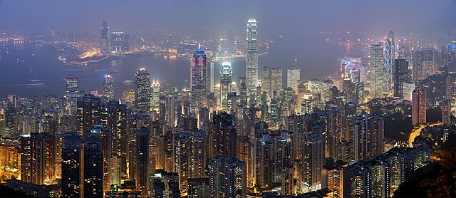
Deutsch: Skyline von Hong Kong betrachtet vom Victoria Peak. Zusammengesetzt aus 78 Aufnahmen (26×3).
English: A 26 segment × 3 exposure (78 frames in total) panoramic view of the Hong Kong skyline taken from a path around Victoria Peak.
Français : Vue panoramique de Hong Kong depuis un sentier de Victoria Peak. Image construite en assemblant 78 clichés (26 visées × 3 expositions) réalisés avecun appareil Canon 5D et un objectif 85mm f/1.8 réglé sur f/5.6. |
| Taariix | |
| Gongikuwaay | Sama liggéey |
| Aji-jëf | Diliff |
| Sañal (Njëfandikoowaatu bii dencukaay) |
Résumé :En utilisant cette image ou toute future œuvre dérivée, vous devez la publier sous la même licence. Par conséquent, toute reproduction de cette image, dans n'importe-quel média, doit apparaître avec une copie, ou un lien vers la licence.Cette image doit impérativement être attribuée à l'auteur (DAVID ILIFF), bien en évidence à proximité de l'image.Aucune autre condition ne peut être ajoutée ou retirée sans l'accord de l'auteur et détenteur des droits.Veuillez prendre connaissance de l'ensemble des conditions de la licence avant d'utiliser cette image. Si vous souhaitez éclaircir les termes de la licence, ou négocier une licence moins restrictive à des fins commerciales, en dehors des limites de la GFDL/CC-BY-SA, veuillez me contacter par e-mail, ou si vous n'avez pas de compte Wikipédia, vous pouvez me laisser un message sur ma page de discussion en indiquant vos coordonnées et votre demande. |
| Autres versions |
|

| Lieu de la prise de vue | | Voir cet endroit et d’autres images sur : OpenStreetMap |
|---|
|
This image was selected as picture of the day on Wikimedia Commons for 6 July 2008. It was captioned as follows: English: Panoramic view of the Hong Kong skyline taken from a path around Victoria Peak Other languages:
Bosanski: Panoramski pogled na hongkoški horizont sa staze kod vrha Viktorija. English: Panoramic view of the Hong Kong skyline taken from a path around Victoria Peak Español: Vista panorámica del distrito central de Hong Kong desde la Cumbre Victoria. Français : Vue panoramique de Hong Kong depuis un sentier de Victoria Peak. Image construite en assemblant 78 clichés (26 visées × 3 expositions) réalisés avec un appareil Canon 5D et un objectif 85mm f/1.8 réglé sur f/5.6. Italiano: Vista di Hong Kong dal Victoria Peak, Cina. Magyar: Hongkongi panorámakép a Viktória-csúcsról nézve Nederlands: Panorama van het stedelijk silhouet van Hongkong, gezien vanaf een pad rond Victoria Peak, de hoogste berg van Hongkong Island Português: Vista panorâmica do distrito central de Hong Kong, feita dos arredores do pico Victoria. Suomi: Näkymä Hong Kongin yli läheiseltä Victoria Peak -vuorelta Беларуская: Панарама Ганконга з гары Вікторыя-Пік. Українська: Панорама Гонконгу з гори Вікторія (Victoria Peak) मराठी: हाँग काँग चे परिदृश्य 한국어: 홍콩 빅토리아 피크에서 바라본 야경. العربية : صورة بانورامية للأفق في هونج كونج. |
| Appareil photo | Canon EOS 5D |
|---|---|
| Ouverture | f/5.6 |
| Objectif | 85 mm f/1.8 |
Cette image a été promue au rang d'image de qualité d'après les critères du Guide des images.
|
Anami Jëfandikoo gi
Moi, en tant que détenteur des droits d’auteur sur cette œuvre, je la publie sous les licences suivantes :

|
Sañalees na duppi, séddale ak/walla soppi bile liggéey ci anami GNU Free Documentation License, Sumb 1.2 walla bépp sumb buFree Software Foundation mujjee siiwal; bu amul benn pàcc bees manul soppi, te amul it menn mbind ci xët wu njëkk week wu mujj wi. Ab sotti bu sañal gi jàppandi na ci pàcc bees duppee GNU Free Documentation License. |
Ce fichier est disponible selon les termes de la licence Creative Commons Attribution 3.0 Non transposée.
- Féeg nga ci:
- séddoo – duppi, séddale ak yónnee bile liggéey.
- soppi – soppi liggéey bi
- Ci kaw yii anam:
- Moomale – Fàww nga joxe ay xibaar yu leer ñeel boroom, joxe ab lëkkalekaay buy jëme ci sañal gi te wax ndax def nga ciy coppite. Man nga koo def ci anam yu bari, ba mu des ci guy wund ne aji-moom ji dafa ànd ak yaw walla ànd na ci ninga koy jëfandikoo)
Man ngaa tànn sañale gi la gënal.
Jaar-jaaru dencukaay bi
Cuqal cib taariix/waxtu ngir gis ni dencukaay bi meloon ca jamono jooju.
| Taariix ak Waxtu | Tuutal | Dayoo | Jëfandikukat | Saraa | |
|---|---|---|---|---|---|
| teew | 29 Awril 2008 à 21:55 | | 4 250 × 1 844 (3,93 Mio) | Diliff | == Summary == {{Information |Description={{en|A 26 segment x 3 exposure (78 frames in total) panoramic view of the Hong Kong skyline taken from a path around Victoria Peak. Taken by myself with a Canon 5D and 85mm f/1.8 lens at f/5.6.}} {{de|Skyline von H |
Njëfandikug dencukaay bi
Amul wenn xët wuy jëfandikoo bii dencukaay.